Choked Fences and Raging Chasms
A century of Hill Country floods

By Ben Christensen, Old Republic Journal
In terms of global geography, the Balcones Escarpment is a modest affair. These central highlands of Texas rise sharply from the plains and prairies below, but only for a few hundred feet of altitude to the vast, south-, southeast-, and east-sloping Edwards Plateau, which was once the ancient continental shelf of southern North America.
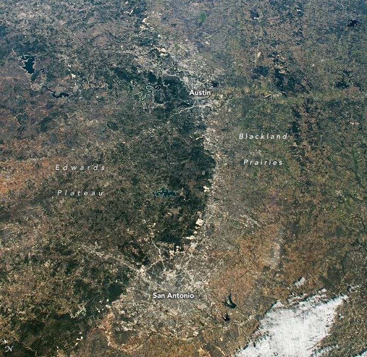
NASA satellite photo illustration of the Edwards Plateau. Retrieved from https://assets.science.nasa.gov/dynamicimage/assets/science/esd/eo/images/imagerecords/151000/151149/iss068e033243.jpg?w=720&h=700&fit=clip&crop=faces%2Cfocalpoint
Typically, towering mountain ranges such as the Rocky Mountains form what is called an orographic barrier. This physical phenomenon affects weather in distinct, predictable ways. The peaks block precipitation-bearing clouds, causing arid western-slope climatic conditions, while ensuring the eastern slope gets ample rainfall.
Although not the true orographic barrier of the Rockies or the Andes, the limestone ramp of the escarpment provides a weather-enhancing physical feature that sends warm, moist tropical air masses from the Gulf of Mexico rolling upward from the low, flat coastal plains to the south and east, launching them high into the atmosphere above the 20 million-acre plateau. Here, they sometimes collide with cool, dry air masses marching southward from the arctic.
Sometimes, tropical moisture streams in through the back door from the west, coming ashore above the Pacific Coast of Mexico, where landfalling hurricanes fall apart. The remnant moisture streaming across the Rio Grande into our Texan skies doesn’t need any orographic enhancement to wreak hydrologic havoc when it collides with cool fronts above the Edwards Plateau.
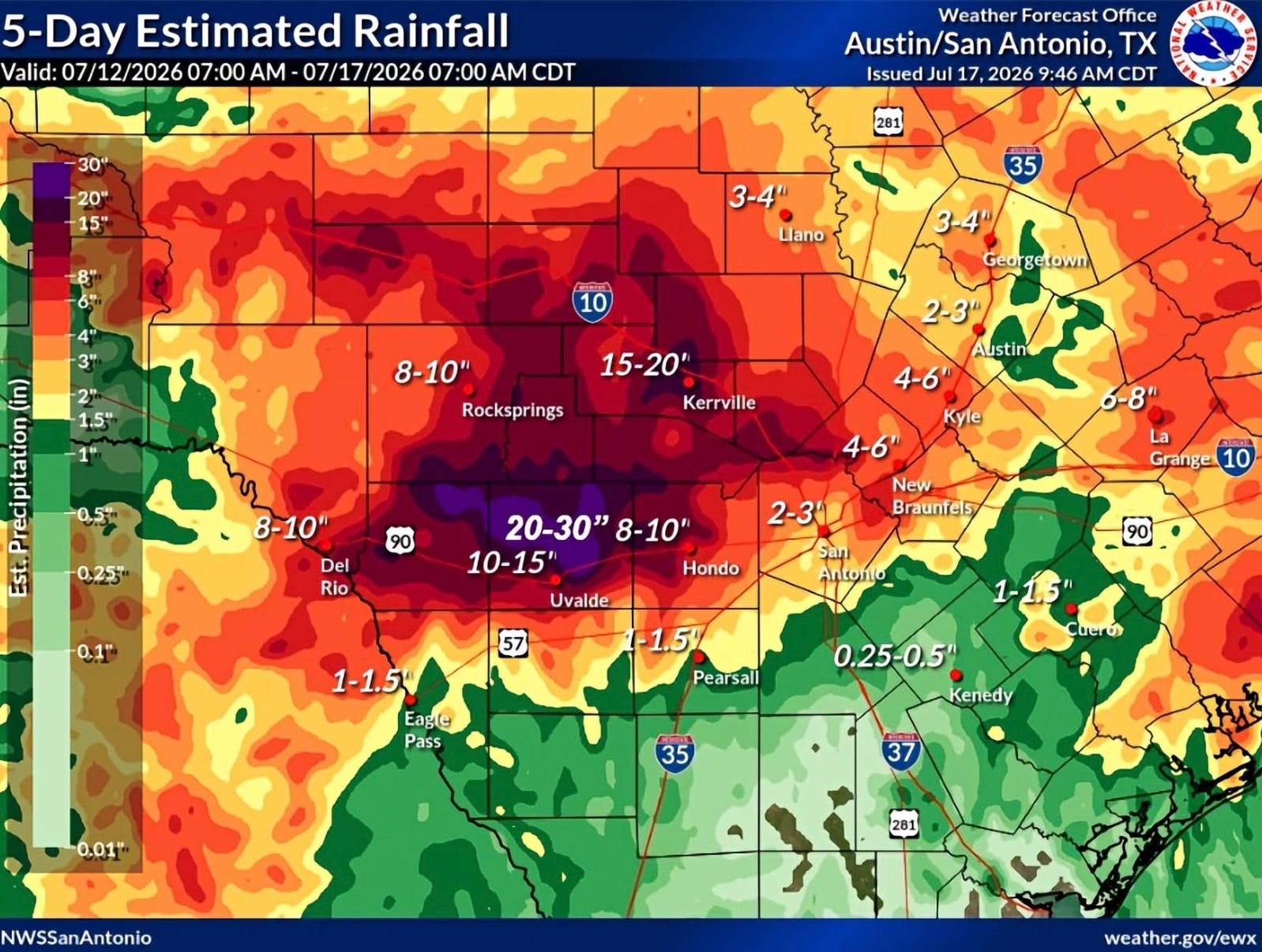
This weather, either the warm, humid Gulf air enhanced by topography or the tropical moisture from the Pacific, frequently triggers staggering flash floods. Rain during these weather-makers can reach 30 to 50 inches (2.5 to 4.2 feet). Floodwaters are sluiced along with the downward slope of the plateau into gullies, ravines, and canyons that funnel the escaping water downstream, where they cascade through the canyon-cut escarpment. This drainage action transforms otherwise gentle Hill Country creeks and rivers into cataclysmic chasms of raging, gray-brown water choked with uprooted pecan, cypress, and sycamore trees. As a consequence of these dangerous geographical and climatological factors, Texas leads the nation by a large margin in flood-related deaths.
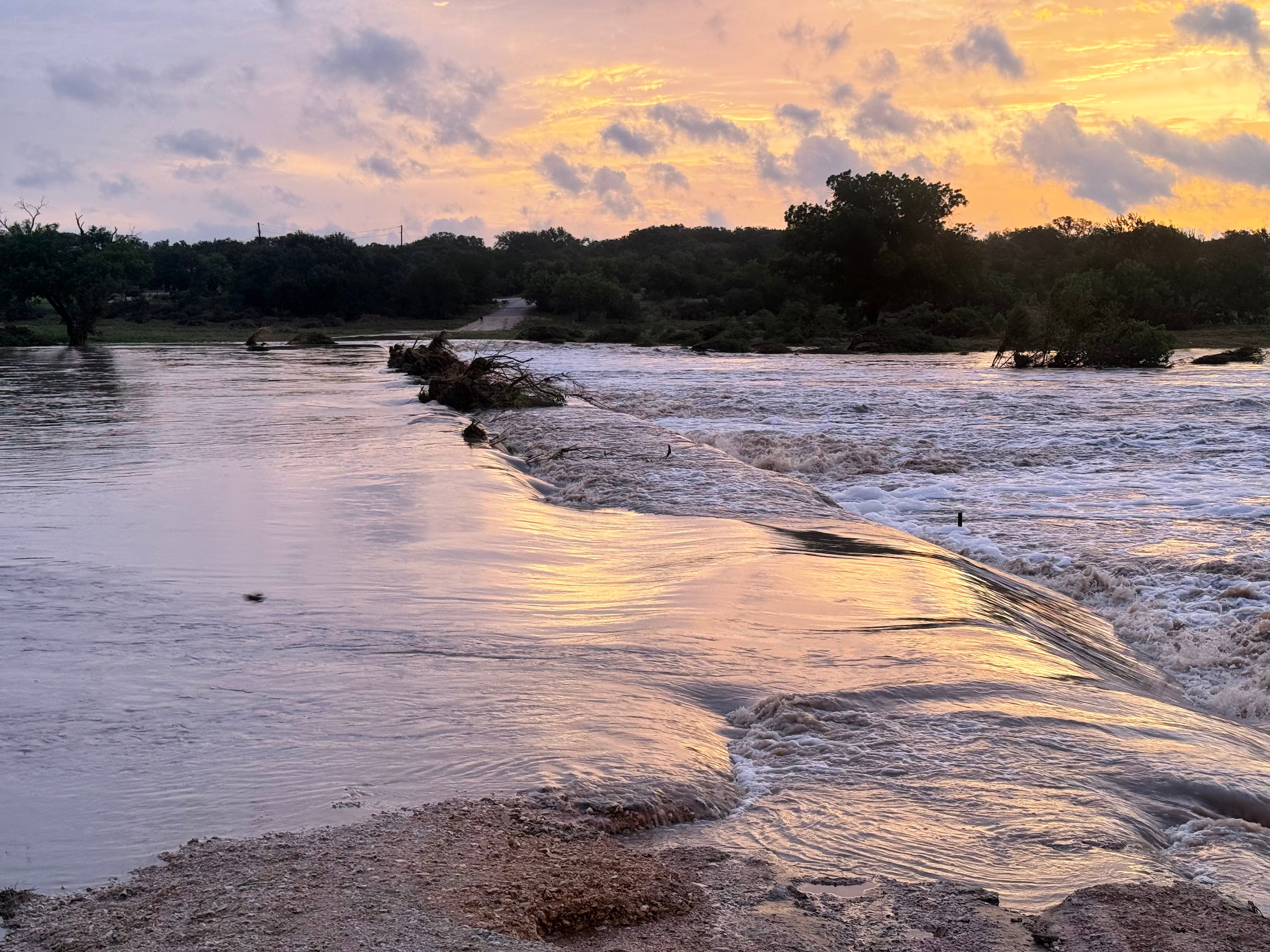
A bridge over the Pedernales River this past Friday, July 17. Photo by Ben Christensen.
Every road that leads you to every fishing spot in the Texas Hill Country is susceptible to flooding. While I haven’t counted them, I guess there are hundreds of signs throughout the Edwards Plateau—a plain, yellow diamond and black lettering, warning us in all caps: “Road May Flood.” In the middle of a drought such signs might draw an eye roll, but don’t get caught far afield among these signs during any persistent rainfall.
The region at the hem of the Balcones Escarpment, and all the Texas Hill Country, is known as “flash flood alley.” This includes the area encompassing I-35 from Dallas-Fort Worth to San Antonio, and along Highway 90 west out to Uvalde. Managers of the Alamo City, which has suffered massive damaging floods throughout its history, invested in amazing flood mitigation infrastructure including a massive, 24-foot-diameter flood-control tunnel deep beneath the entire three-mile reach of the Riverwalk through downtown. Austin’s propensity to flooding was a primary motivation for the construction of the five Highland Lakes that stretch all the way from Inks Lake just south of Colorado Bend State Park southeast into Lady Bird Lake in downtown Austin.
Per example, the Llano River was once known for the abundant, centuries-old pecan trees crowding its banks, providing ample cooling shade the way they still do along the Colorado River around San Saba. But the June 14, 1935 flood of record—the worst recorded flood on the Llano to date—erased them. A 43-foot crest scrubbed the bankside groves—and the dirt that nourished their roots—the way you would blast lichens from a sidewalk with a pressure washer.
During that event, tropical moisture inundated the area that includes the topographical divide between the west-flowing Llano and the south-flowing Frio and Nueces, overwhelming their headwaters and compounding a disastrous, multi-river flood. The North Llano, a favorite tributary of mine, reached a peak I can hardly imagine—28 feet.
This water piled into the Llano’s mainstem, washing away the bridges in the towns of Llano, Castell, Hedwigs Hill, and over the Colorado on the south side of Marble Falls. This same flood inundated much of Austin, on the Colorado River downstream, which peaked at 41.2 feet. This was just one foot shy of what was the worst flood in Austin on record, in 1869.
According to a 1937 U.S. Geological Survey report of the flood, which peaked on the Llano at 388,000 cubic-feet-per-second (CFS), “thousands” of pecan trees were lost in the ’35 flood, scouring the soil to the rock.
The Nueces and Frio also took it on the chin. A steel railway bridge west of Uvalde was swept away where the flood waters peaked at 36.9 feet. That surpassed the previous record set in June, 1913, when the Nueces rose to 29 feet in Laguna at 213,000 CFS. By comparison, USGS Stream Gauge 08190000, the Nueces River at Laguna, crested at 21.51 feet this past Thursday, July 16 at 3:10pm local time.
On June 18, 1935, cut off by the flood, Camp Wood residents had to rely on food supplies dropped by air. The 1935 flood killed 30 people, but folks upriver were considerate enough to use the telephone to call folks downriver and warn them, allowing people to move to higher ground before the crest hit.
The Pedernales River’s Flood of Record
September 11, 1952, saw the worst-on-record flood on my beloved home waters, the Pedernales River. I remember being riveted by the late Alvin “Bunny” Weinheimer’s firsthand tales of that one. At the time, Bunny, who died in December, 2020, at the age of 90, worked with his father at Stonewall’s landmark Weinheimer & Son general store (which is still in business in Stonewall, owned by his daughter, DeAnn Hampton). He recounted the water coming all the way up to Highway 290, stranding motorists who had to climb into trees, clinging onto limbs to keep from being swept away. He told me of one family who had lost a young son in the flood and how heart-rending it was. That flood killed five people.
The 1952 Pedernales River flood of record saw a maximum crest at a mind-boggling 40.8 feet and 441,000 CFS. By comparison, this past Thursday’s peak reached 34.32 feet.
It is my personal belief that you can tell old timers’ riverside ranches from newer owners because of the way many properties along the Pedernales River around Stonewall have fences that: one, actually retain livestock, and two, end at least 50 yards up from the river. I noticed several fences plowed flat by the floodwaters, and others that were installed well away from the bank only had dried grass hanging off the barbed wire strands when I checked the crossings this past Friday morning.
If you know Fredericksburg-area farmers and ranchers like I do, you know they aren’t keen on paying for fences that they’re going to have to re-build every time there’s another flood!
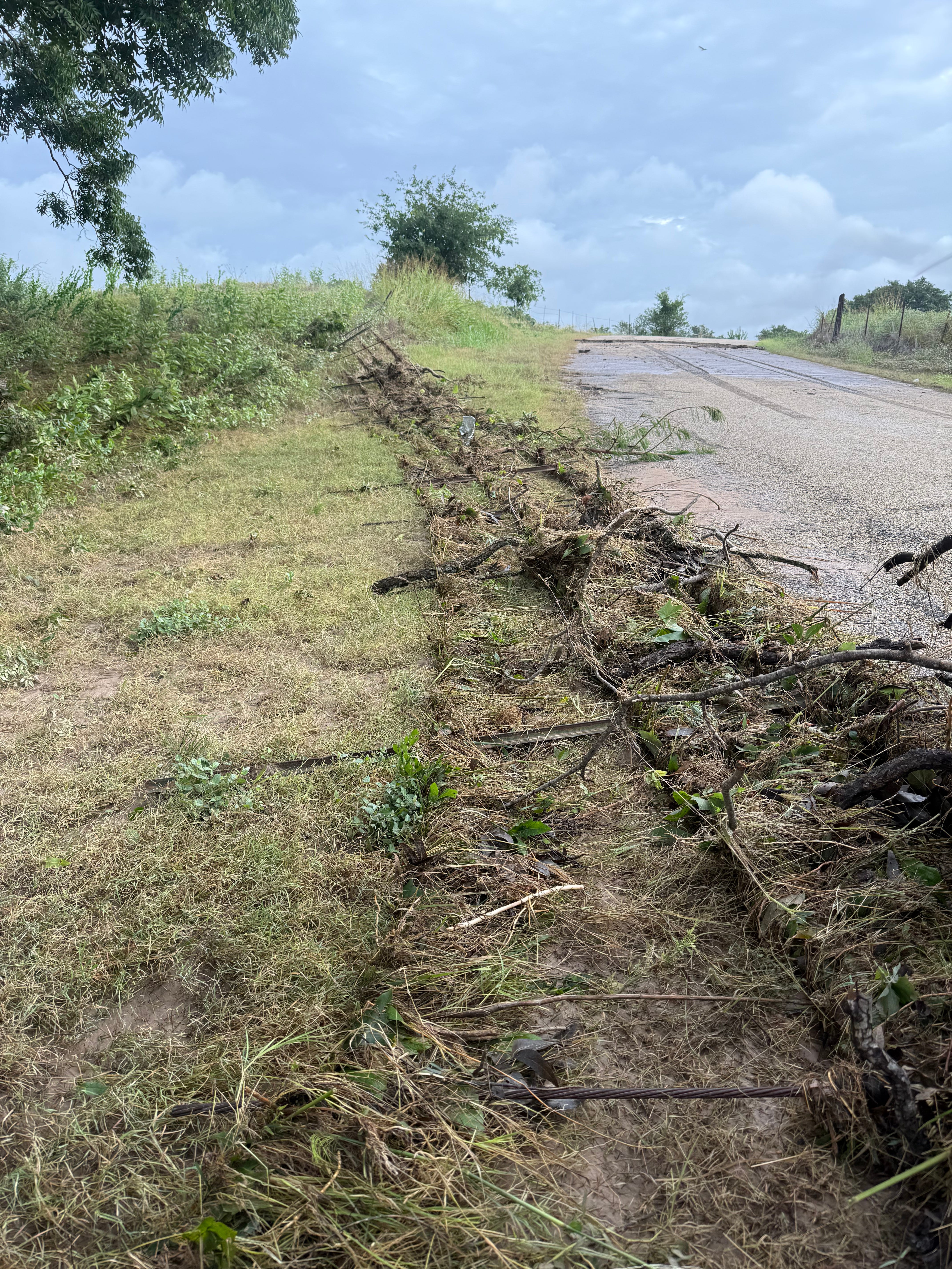
The river doesn’t give a damn about fences. Photo by Ben Christensen.
The Guadalupe River
Unfortunately, we can’t get away from the flood metric that matters most of all when comparing historic floods on the Guadalupe River: human lives lost.
This past Thursday, July 16 at 5:10am, the Guadalupe registered a crest of 37.69. This time, all but Mark Steward, a beloved 1979 graduate of Westlake High School killed in this week’s flood, got out of the way.
The worst flood, of course, was the July 4th, 2025 event that caused the heart-rending loss of 119 people along the Guadalupe alone. The one that claimed 27 campers and the camp administrator of Camp Mystic. The one caused by a tremendous deluge of water that occurred most severely between 1:00am and 5:00am. Last year’s flood was the most massive flood for which we have USGS flood gauge data, with a crest of 39.61 feet at USGS 0816620 near Center Point. That’s the gage downstream of Camp Mystic (which was nestled in and along a canyon on the South Fork of the Guadalupe), and downstream of more than a half-dozen campgrounds that were packed on that Fourth of July, which fell on a Friday.
Before last year’s flood, the deadliest flood on the Guadalupe happened July 17, 1987. In that flood, when a school bus and a van carrying 39 teenaged campers from Pot O’ Gold Camp, located two miles upriver from Comfort on the Guad, were swept away. Ten of the teenagers drowned. Like last year’s tragedy, that flood was an overnight event. Unlike last year’s tragedy, by 4:35am Camp Mystic reported all their campers were safe.
Y’all stay safe out there. -Ben